 Picto-Occitanie
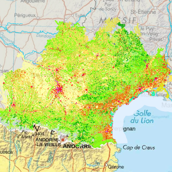
[DREAL OCCITANIE] Corine Land Cover 2018 en Occitanie
Simple
- Date (Revision)
- 2021-12-13T15:14:45
- Date (Publication)
- 2017-10-20T00:00:00
- Date (Creation)
- 2017-10-20T00:00:00
- OPENDATA
-
- données ouvertes
- open data
- Plateforme Occitanie - mots clés géo
-
- OCCITANIE
- GEMET - INSPIRE themes, version 1.0
-
- Usage des sols
- Domaines
-
- DREAL
- N_OCCUPATION_SOL
- PUBLIC
- Domaines
-
- N_OCCUPATION_SOL
- PUBLIC
- DREAL
- Use limitation
- Aucune condition d'accès ne s'applique. Utilisation libre sous réserve de mentionner la source (a minima le nom du producteur) et la date de sa dernière mise à jour
- Access constraints
- Other restrictions
- Other constraints
- Pas de restriction d’accès public selon INSPIRE
Resource constraints
- Spatial representation type
- Vector
- Denominator
- 100000
- Metadata language
- fre
- Character set
- UTF8
- Topic category
-
- Imagery base maps earth cover
- Description
- OCCITANIE
))
- Reference system identifier
- EPSG / RGF93 / Lambert-93 (EPSG:2154) / 7.4
- Distribution format
-
-
ESRI Shapefile
(
1.0
)
-
ESRI Shapefile
(
1.0
)
- OnLine resource
-
CLC_nomenclature.xls
(
WWW:DOWNLOAD-1.0-http--download
)
Nomenclature
- OnLine resource
-
CLC12.pdf
(
WWW:DOWNLOAD-1.0-http--download
)
Métadonnée nationale
- OnLine resource
-
clc_r76
(
OGC:WMS-1.1.1-http-get-map
)
clc_r76
- OnLine resource
-
clc_r76
(
OGC:WFS-1.0.0-http-get-capabilities
)
clc_r76
- OnLine resource
- Accès au téléchargement des données ( WWW:DOWNLOAD-1.0-http--download )
- OnLine resource
- Accès à la visualisation des données ( WWW:LINK-1.0-http--link )
- OnLine resource
- Accès au lien ATOM de téléchargement ( WWW:LINK-1.0-http--link )
- Hierarchy level
- Dataset
Domain consistency
Conformance result
- Date (Publication)
- 2010-11-23
- Explanation
- cf. la spécification citée
- Pass
- Yes
Conformance result
- Date (Publication)
- 2010-05-03
- Explanation
- cf. la spécification citée
- Pass
- No
- Statement
- Extraction sur le territoire de l'Occitanie de la couche nationale Corine Land Cover 2018
- Feature catalogue citation
- Feature catalogue citation
- Feature catalogue citation
- File identifier
- 7a93677b-4f9c-472c-a569-07efb54735eb XML
- Metadata language
- fre
- Character set
- UTF8
- Hierarchy level
- Dataset
- Date stamp
- 2021-12-13T15:18:59
- Metadata standard name
- ISO 19115:2003/19139
- Metadata standard version
- 1.0
Overviews
Spatial extent
Provided by
